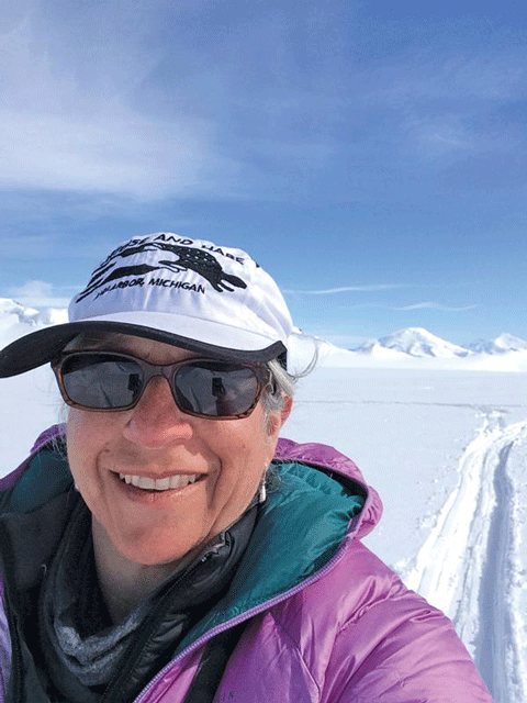
Dual perspectives of art and science drive the work of Ann Arbor wilderness and environmental artist Leslie Sobel. Sobel integrates art with scientific field research to help spread awareness of climate change and stimulate efforts toward mitigation. Her work focuses on the environment and the ways people change, understand and interact with it, drawing on the concept of solastalgia–a term coined by Australian philosopher Glenn Albrecht meaning “grief for a place that you may not have ever been, but that you know is disappearing”.

Sobel balances wilderness fieldwork in remote places alongside climate scientists, with time spent in the studio creating art based on her observations of the effects of global warming to illustrate “our disconnect from the natural world”. For instance, in 2013, she travelled to Colorado to participate in a wilderness-based residency project at the Canyons of the Ancients National Monument as part of a US Forest Service program that sent artists to work with scientists in locations across the US and Canada to study the effects of climate change.
Four years later, in 2017, Sobel accompanied two climate scientists and two grad students from the University of Maine’s Climate Change Institute to the Canadian Yukon on an eight-day research expedition to the Eclipse Icefield in the St. Elias Mountains in Canada’s Kluane National Park. Encamped on the glacier 10,000 feet above sea level, Sobel worked with the group to document the recession rate of the glacial melt and consequent diversion of the course of nearby rivers, called “river poaching”.
Sobel believes that artists can effectively advocate for the environment and scientific research by helping people experience places affected by climate change that they will likely never get to see, places that may never be the same again as the world warms.
Sobel’s work illustrating the effects of climate change over time is representative of the United Nations Sustainable Development Goals 6 on Clean Water and Sanitation, Goal 13 on Climate Action, and Goal 14 on Life Below Water.
As the artist daughter of two scientists, Sobel’s passion for both art and science started young. Her mother was a chemist and middle school teacher, her father an electrical engineer and physicist who “invented some of the earliest flat-screen panels”, and her brother is a geologist. Growing up in Chicago and New York, she enjoyed the art and photography classes she attended but also relished experimenting with the microscope her parents gave her. Sobel came to Ann Arbor to study art at the University of Michigan, where she obtained her Bachelor of Fine Arts degree in 1983 and met her husband Bill Worzel, who became a computer scientist.
After marriage in 1985, Sobel and Worzel ran a successful software company, Arroyo Software, in Ann Arbor while raising their three children. She completed her master’s degree coursework in Interdisciplinary Technology at Eastern Michigan University, College of Technology, in Ypsilanti, Michigan, in 1997 and earned her Master of Fine Arts degree from the University of Hartford, Connecticut, in 2020.
In making her artworks, Sobel draws upon her experience as a tech entrepreneur, often incorporating digital imagery including mapping and satellite images produced by scientists with traditional art materials. Although climate change had been important to Sobel long before she became an environmental artist, it was not until 2005, when she chaperoned a high school service field trip to New Orleans after Hurricane Katrina, that she began documenting its effects in her art.
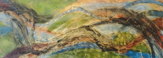
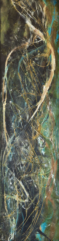
Sobel says that the post-Katrina trip to New Orleans made the power and significance of the Mississippi River “painfully, viscerally, real”. One of her artistic responses to the trip has been an ongoing series of encaustic (hot wax) monotypes of the Mississippi watershed entitled Abstract Aerials that she began producing in 2007. A monotype is a single print taken from a design created by drawing or painting on a smooth, non-absorbent surface usually of glass or metal.
Five monotypes from the Abstract Aerial series were featured in the 2012 exhibition, “Watershed Moment” to celebrate the grand opening of the Art and Environment Gallery inside the University of Michigan’s School for Environment and Sustainability (SEAS) curated by fellow artist and applied aquatic ecologist, Sara Adlerstein-Gonzalez.
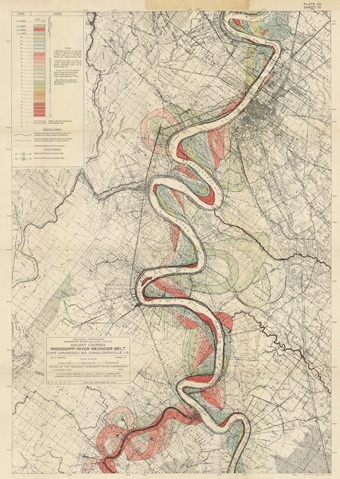
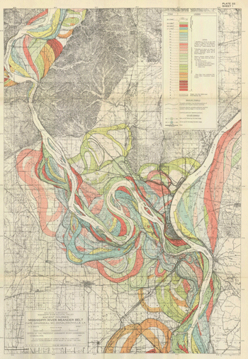
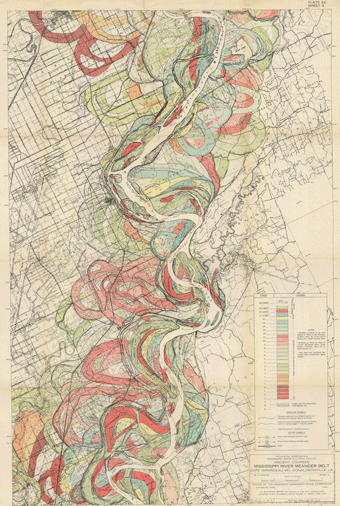
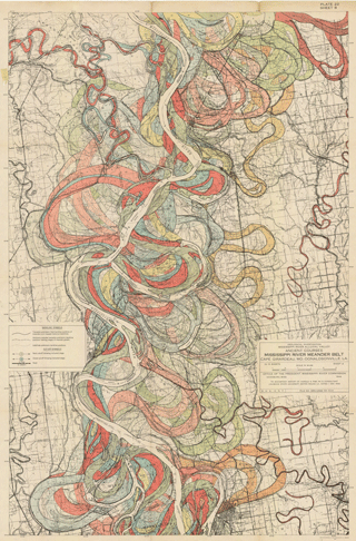
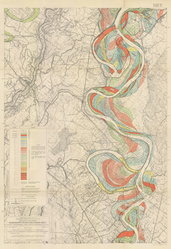
The 29 monotypes in the Abstract Aerial series were inspired by both the 2005 trip to New Orleans and her discovery of a series of 15 meander belt maps of the Alluvial Valley in the Lower Mississippi River from 1944 drawn by Harold Fisk (1871-1960), a former Major General in the United States Army, geologist and cartographer for the US Army Corps of Engineers. Fisk’s 1944 maps represent the lower Mississippi’s “meander belt” — the area of a valley bottom across which a river’s channel has shifted over the millennia. The meander belt of the Mississippi — which has the fourth largest watershed in the world–is immense. The river courses some 2,350 miles from Lake Itasca in Minnesota to the Gulf of Mexico in Louisiana.
Fisk produced his maps for a government report on “the nature and origin of the Alluvial Valley of the Lower Mississippi River”. He drew the current course of the river in 1944 terms as “represented by a mighty blank, punctuated by islands, and crisscrossed by the serpentine green course of 1880, the salmon-pink course of 1820, and the light blue course of 1765”.
In addition to these courses, one can see the colour-coded traces of where the river flowed even earlier, stretching back to prehistoric times. Understanding the meander belt is important because the meandering of a river represents potential danger to people and structures located along its path, especially in times of flood.
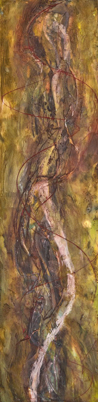
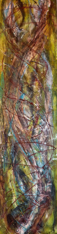
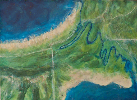
To create some of her monotypes in Abstract Aerial, Sobel began by making digital images from Fisk’s maps, enhancing, interpolating and enlarging them. To represent the Mississippi’s fluctuations over time, Fisk used overlapping lines and colours, a technique Sobel drew upon with her monotypes. In making Crystal River (2015), the single zigzagging strand she uses references Fisk’s Mississippi River Meander Belt map 15.
Another 2015 work from the series, Overlaid Rivers references the overlapping yellow, blue, green, red and orange colours, and thick, looping lines of Fisk’s Mississippi River Meander Belt map 1.
A set of vertical monotypes in the Abstract Aerial series, Scribed Channel Variations 1-3 also from 2015, evokes Fisk’s Mississippi River Meander Belt maps 4, 8 and 14.


Since becoming a full-time artist in 1998, Sobel has also produced exhibitions, served as both a juror and judge for numerous art fairs and fine art presentations, written grants, curated and installed various exhibitions, lectured, and organized additional programing. She has exhibited her own work across Michigan and taught art classes both in her Ann Arbor studio and at various institutions around the state. Sobel’s intent is to make an environmental message accessible without being intimidating:
“A big part of what I do is really focused on taking scientific data and making it accessible and emotive because people don’t change behavior because of numbers….
They change behavior because of something that touches their feelings. I think it’s critically important to take scientific information and make it emotionally accessible, and meaningful, to people who are not scientists.”
By using art to connect climate change, water, and scientific data, Sobel educates viewers while appealing to their emotions. To learn more about Leslie Sobel and her many projects, visit her website.